

Mount Rainier
Images of Mount Rainier National Park
1966-1969
"Into a cloud sea far below, I lonely watch the red sun go,
Then turning, miracle of glad surprise, Enchanted saw the full moon rise."
— Clark E. Schurman
Chief Guide, Mount Rainier, 1939-1942
(from a plaque at Camp Schurman)
It was 1966. Vietnam was more than an exotic name on a map. The so-called "60s" were in full swing. After two years of university and under constant threat of the military draft, I was looking for a summer place to escape the increasing madness and study what I had always loved, the wilderness. When my application for employment was accepted by the US National Park Service, I jumped at the opportunity.
In the summers of 1966 through 1969, I worked as a Seasonal Fire Control Aide (1966) and Seasonal Ranger at Mount Rainier National Park in Washington State. These were ideal summers where I learned much, not only about employment and the role of the civil servant but also about national parks, mountains and mountain climbing, and the importance of wilderness and wild places to the soul. Most important, I met my future wife, Betty, and some great friends—together with whom we created some long lasting memories.
The following images were scanned from 35 mm film slides:
by Don H. Meredith
Mount Rainier—The Park

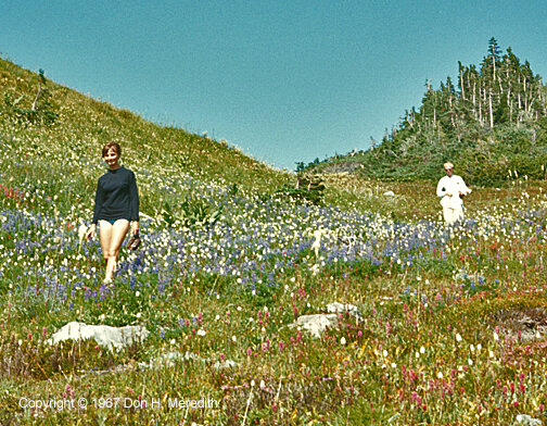
The wildflower meadows of Paradise Valley
Mount Rainier is a dormant volcano, one of many in the Cascade Mountains of Washington, Oregon and California. It has the largest mass of any mountain in the lower 48 United States. Mt. Rainier also has the most extensive glacier system of any such mountain. It has been used as a training ground for mountaineers practising their ice climbing skills before venturing into the Himalaya.
In 1966, I was employed as a seasonal Fire Control Aide, which was really an apprentice ranger position. While in training for our duties at Longmire, I met Tim Hall and we became fast friends. He and I ended up on the Sunrise side of the mountain. This turned out to be an ideal posting for me because Sunrise was off the well-beaten tourist path. Sunrise was also a beautiful part of the park, being near timberline with magnificent views of the mountain and easy access to many of the nearby wilderness trails. Tim and I shared the duty of manning the Mount Fremont Fire Lookout Tower. He spent five days a week at the tower and I spent two, covering his days off. When not in the tower, I assisted the rangers at Sunrise.
In 1967, I was hired as a Seasonal Park Ranger, where I served at Lake James, a backcountry posting in the northeastern portion of the park. In 1968, I served as a ranger at Sunrise. In 1969, I took part-time duties as a ranger at Sunrise, while I conducted a graduate study in alpine ecology in Huckleberry Park, just north of Sunrise. As part of my ranger duties that year, I served as the climbing ranger at Camp Schurman on weekends. The following photographs are taken from all four years.

Slide 1 — Mount Rainier from Paradise (south) side in June of 1966
Driving up the Columbia River gorge on a bright sun-drenched day in early June of 1966, I was feeling the excitement and apprehension of heading to a new job. I was 20 years old and had just finished my sophomore year at Oregon State University, studying zoology. I had signed on as a Fire Control Aide at Mount Rainier National Park, a place I had never visited and where I knew not a soul. My 1963 Plymouth Valiant was packed full of my earthly goods as I started out on a grand adventure that would change the arc of my life.
The following day I showed up for work at the park headquarters in Longmire on the south side of The Mountain. There I met our class of Fire Control Aides, mostly students like me, excited about having an outdoor job in a spectacular place.
At Longmire, we took Fire Control School, where we learned about the nature and danger of forest fires, how to predict them and how to fight them. We sharpened axes, pulaskis and shovels, practised digging fire lines, learned how to record fire weather and safely run a chainsaw. We also practised orienteering.
We took a field trip to Goblers Knob, a fire lookout on the southwest side of the park. There we learned how to run a lookout, from pinpointing the location of fires using a firefinder to using two-way radios to communicate with park headquarters.
After Fire Control School, we were given our assignments around the park. Although I did not know it at the time, I was lucky to be assigned to Sunrise on the northeast side of the park and away from the more popular areas. Three of us went to Sunrise—Tim Hall, Delbert Wondergem and myself. Tim was assigned to man the Fremont Lookout for five days a week. I was to man the lookout the two days of Tim's days off; the other three days I helped the rangers at Sunrise. Delbert was assigned to the backcountry of Lake James on the Northern Loop Trail where he stayed in a patrol cabin.

Slide 2 — Mount Rainier from Sunrise Point on the road to Sunrise

Slide 3 — Some of the national park crew at Sunrise, 1966:
(l-r) Winn Erickson, Paul Myher, Don Meredith, Frank Bell and Tim Hall
Another thing I did not know at the time was that we were extremely lucky to have Frank Bell, the Sunrise Area Ranger, as our immediate boss. Frank was a professional ranger, understood the role of rangers and other civil servants in the national park service and passed that knowledge on to us. However, he conducted business with a good sense of humor and realization that we were all there to learn. He was a joy to work and serve with.

Slide 4 — At an elevation of 1950 metres (6400 feet), Sunrise only had a few snow-free weeks in summer. Here, Tim Hall stands in the parking lot in front of the visitor center and ranger station after a June snow storm.

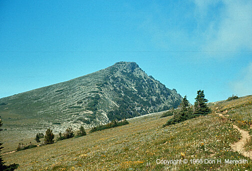
Slide 5 — Mount Fremont Fire Lookout
Mount Fremont Lookout is located northwest of Sunrise. It is accessed via a 9 km (5.6 mi.) trail. The views from the lookout are spectacular. On clear days you can see all the way from Mt. Rainier to Seattle and Mount Baker beyond.

Slide 6 — The Fire Finder at Mount Fremont Lookout

Slide 7 — Mount Fremont Lookout from trail to Sunrise

Slide 8 — Mount Fremont from Burroughs Mountain, Mount Baker in the distance

Slide 9 — Mount Rainier from Mount Fremont Lookout

Slide 10 — Mount Fremont Lookout from Grand Park, north of the lookout.

Slide 11 — A double exposure of the lookout and Mt. Rainier.

Slide 12 — Don on Burroughs Mountain with Mount Rainier beyond.
The beauty of working in a national park if you are an outdoors person is you don't have to go far to recreate on your days off. Mount Rainer NP has some of the best hiking trails you will find anywhere, especially when considering the views you see. They can be challenging or easy, depending on what you want to do on a particular day. The park also has some interesting mountain climbing options. An additional benefit of working in a national park is you are working with many people having similar outdoor interests, so it isn't hard to find someone to hike or climb with.
Close to Sunrise is Burroughs Mountain that offers some spectacular views of The Mountain and surrounding country.

Slide 13 — Sourdough Ridge above Yakima Park and Sunrise from Burroughs Mountain

Slide 14 — LIttle Tahoma from Burroughs Mountain.

Slide 15 — Frozen Lake from Burroughs Mountain. Frozen Lake was the water source for Sunrise (clean snow-melt water). We fire control aides at Mt. Fremont L.O. would haul water (in water backpacks) from Frozen Lake for our potable water. You can see the Fremont L.O. trail going up on the left of Frozen Lake.
Slide 16 — Skyscraper Mountain along the Sourdough Ridge
Above Sunrise is Sourdough Ridge with its series of peaks. One of those peaks is Skyscraper Mountain where you can get some great views of northern Mt. Rainier park.

Slide 17 — Looking north from Skyscraper Mountain onto Grand Park.

Slide 18 — Trail to Berkeley Park.
Trails going north of Sunrise take you to some incredible "parks", where wildflowers and wildlife are abundant.

Slide 20 — Through most of the summer, wildflowers are abundant in meadows throughout the park.
In June of 1967 I finished my Junior year at Oregon State University. The 1966-67 academic year had been tumultuous on campus as opposition to the Vietnam War heated up (even at conservative OSU). There were demonstrations and the military draft was the chief topic of conversation among males whose student draft deferments were constantly under threat. The war machine needed bodies.
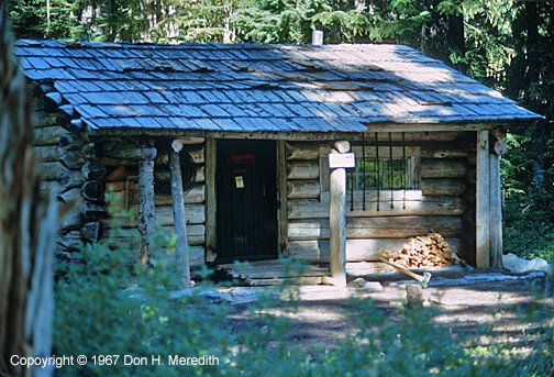
Slide 21 — Lake James Patrol Cabin on the Northern Loop Trail.

Slide 22 — Sunrise in early June after the snowplow finally made its way through the deep snow.
In June I gladly returned to Mount Rainier NP to resume my job as a Fire Control Aide, hopefully back in Sunrise where many of my friends were also returning. However, upon arrival at Longmire (the Park HQ) I learned (after much haggling with the powers that be) that the only way I could return to Sunrise would be as a Seasonal Ranger at the Lake James Patrol Cabin in the backcountry of the Northern Loop Trail. My only other option was to work a 9 to 5 office job in Longmire as the senior Fire Control Aide in charge of compiling the fire weather and coordinating the radio traffic with the fire lookout towers. As far as I was concerned, it wasn't much of a choice. At Lake James I would be working on my own in the backcountry, a dream job for an aspiring wildlife biologist, plus I had a promotion. Also, I would be based out of Sunrise, where I would spend my days off. So, I soon found myself back at Sunrise preparing for my stay at Lake James.
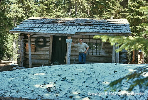
Slide 23 — Don on arrival at the Lake James patrol cabin. District Ranger Jim Valder brought Don's supplies and gear for the summer on horseback.

Slide 24 — The Northern Loop Trail is an alternative to the Wonderland Trail that circles Mount Rainier. It is about 24 km (15 miles) long from Sunrise to Carbon River through some spactacular backcountry. I would sometimes take The Northern Loop Trail from Lake James to Sunrise as part of my duties to patrol the trails, talk with visitors and report issues.

Slide 25 — Lodi Creek on the Northern Loop Trail between Sunrise and Lake James.

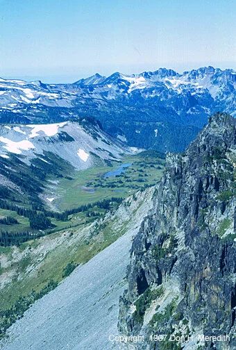
Slide 26 — Lake James from Independence Ridge on the Northern Loop Trail.
Lake James was a favorite with local anglers who hiked up on weekends, usually from the north park boundary following the West Fork of the White River. They camped at the Lake James campground and fished for the trout that had been stocked there over the years (fish stocking ceased in 1973). The fishing was good and I often caught a few trout to supplement the canned and dried food I had waiting for me at the cabin.
During the week most of the campers were people hiking the Northern Loop Trail. One of my jobs on the weekends and during the week was to visit with the campers, check fishing bag limits and remind people they were in a national park.
Lake James is part of a group of five lakes (James, Ethel, Marjorie, Oliver and Adelaide), which in those days were connected by an angler's trail. Because access to the other four lakes took a bit more effort, the fishing could be better there than at Lake James. So, part of my job each weekend was to hike the five or so kilometres (three+ miles) to the lakes to ensure people were not camping there and they were following park regulations.

Slide 27 — Lakes Ethel (right) and Marjorie from Independence Ridge. Lakes Oliver and Adelaide are just visible as forest openings on the bench above and to the left of Marjorie.
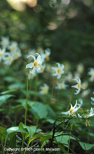
Slide 28 — As the snow receded in June and July, two types of lilies would appear. This is the avalanche lily. Its more common cousin is the glacier lily that looks exactly the same, except it is yellow.
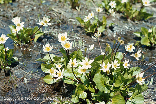
Slide 29 — Marsh Marigolds are found in wetlands shortly after the snow leaves.

Slide 30 — The Natural Bridge just below Independence Ridge.
Radio reception at the cabin could be a bit sketchy at times. Most often I could only contact the Mount Freemont Lookout Tower and have Ron Bannister, the Fire Control Aide there, relay messages for me either to or from Sunrise or the Chief Ranger Office in Longmire.
During the latter part of August the entire park was closed to the public because of extreme forest fire danger. After ensuring that all hikers and campers had vacated my area, each day I hauled my radio (in those days a heavy tube radio) up to the top of Independence Ridge just west of Lake James and sat and watched for smokes in or just outside the park. Radio reception was excellent on the ridge and, between Ron Bannister and I, we had a good handle on the northeast portion of the park. Fortunately, no serious fires got started in the park, but there were several in the national forests outside the park.

Slide 31 — The Northern Loop Trail crosses Independence Ridge at Windy Gap. Just below Windy Gap is Crescent Lake.
Another job I had that summer was to hike the Northern Loop trail west from Lake James to Carbon River and then back to Sunrise along the Wonderland Trail. I was to check on trail and campground conditions.

Slide 32 — At Carbon River, a side trip takes you to Eunice Lake where there is an excellent view of Mount Rainier from the northwest.

Slide 33 — A view of Willis Wall from the Wonderland Trail. Willis Wall rises some 1200 metres (4000 feet) above the Carbon Glacier and is topped by ice cliffs coming from Liberty Cap, the third highest summit on The Mountain. Constant rock and ice fall make Willis Wall the most difficult and dangerous climbing route on Rainier.
From Carbon River I returned to Sunrise via the Wonderland Trail. The trail passes close to The Mountain providing excellent views of Willis Wall, Steamboat Prow and the Winthrop Glacier.

Slide 36 — The terminus of the Winthrop Glacier, source of the West Fork of the White River.

Slide 35 — The Winthrop Glacier coming down from the summit of Mount Rainier between Steamboat Prow and Willis Wall.

Slide 34 — A view of Steamboat Prow from the Wonderland Trail. At the top of the prow is Camp Schurman, the high camp for climbers on this side of the mountain.
As in most jobs, I had two days off a week (although in reality we were on call 24/7 in case of emergencies). These occurred during the week (when there were fewer people in camp). I would sometimes go into Sunrise to buy groceries, wash clothes and connect with friends. Other times I would spend at Lake James, getting to know the country and the fishing at the five lakes. Sometimes friends at Sunrise would come see me at Lake James.
Slide 37 — Marcia Hamann and Winn Erickson hiking on Windy Gap.

Slide 38 — Sluiskin Mountain from Packtrain Ridge. Sluiskin Chief is the highest peak (2142 metres; 7026 feet). The climb is a rock scramble with some chimney stemming (if memory serves) in the last pitch to reach the summit.
On one such occasion, friend Winn Erickson hiked up from Sunrise in a surprise visit and announced that he and I were going to climb Sluiskin Mountain, not too far from Lake James. I had seen the mountain from Grand Park and Windy Gap and knew it would provide some great views. So, early the next morning we set out.

Slide 39 — Sluiskin Mountain from Grande Park. The mountain is made up of rock that is older than Mount Rainier.

Slide 40 — Winn Erickson on our scramble to Sluiskin Chief

Slide 41 — Windy Gap from the summit of Sluiskin Chief

Slide 42 — The view of Grand Park from Sluiskin Chief
Slide 43 — The Elysian Fields from Sluiskin Chief summit. Named after the "final resting place of souls" in Greek mythology—or indeed "paradise on earth", these meadows are some of the most remote in the park. To reach them you must do some off-trail hiking from Windy Gap.

Slide 44 — Sunrise from Sourdough Ridge
The summer of 1968 found me back at Sunrise as a seasonal ranger. This time, the powers that be decided the Lake James job should go back to a fire control aide and that I was needed to help Frank Bell at Sunrise. Gary Wolfe was the new Fire Control Aide at Lake James and I went with him on his first trip to the lake to show him the ropes and help him get started in the backcountry job. He was as enthusiastic about the job as I had been. We both shared the same love for wilderness, creating what turned out to be a long-time friendship.
For me Sunrise was good duty with a lot more responsibility and opportunties for different adventures. I also met Betty Ringel, who worked in the souvenir shop of the Sunrise Lodge.

Slide 45 — During 1968 some ice caves opened up at the terminus of the Paradise Glacier on the south side of the park. The park service established a trail from Paradise so visitors could view the caves.

Slide 46 — Inside the ice cave with Betty Ringel.

Slide 47 — The rescue crew getting ready to take the climber down from a col. The poor weather and restricted visibility made it difficult to extract the man. The climber is in the akia or rescue sled, equipped with handles to facilitate travel on snow.
One of the responsibilities all national park employees have is to be on hand to help out in any emergencies, such as fires and mountain climbing or hiking accidents. The following photos I took during a mountain rescue of a climber who broke his leg climbing the South Cowlitz Chimney on the east side of Mount Rainier.
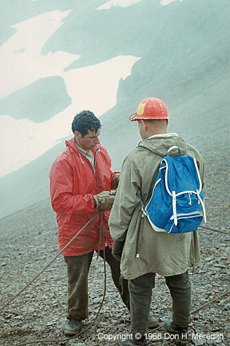
Slide 48 — Ranger John Dalle-Molle checking knots with Cliff Wiegel.

Slide 49 — Here we're lowering the man in the akia down some difficult terrain. Care was always taken to ensure the safety of the injured and the rescue personnel, skills taught at climbing school and through experience.

Slide 50 — My Huckleberry Park study area in June
In 1969 I returned to Sunrise as a part-time Seasonal Ranger. Over the course of the summer of 1968 I received an offer I could not refuse from Central Washington State College (now a university) to continue with my education and work towards a master's degree in biology. Because I wanted to do research in mountain ecology, I was able to work out a deal with the park service to work just three days a week (over the weekends) and leave me four days a week to conduct my study on the ecology and behavior of small mammals in Huckleberry Park just over Sourdough Ridge from Sunrise.

Slide 51 — Betty chatting with a marmot, just visible below her.
This arrangement fit well with me. It also worked for the park service. As it turned out, more and more people were coming to the park to climb The Mountain. This resulted in more accidents, most of which occurred on the weekends. So, in 1969 it was decided that a ranger needed to be stationed at the Camp Schurman high camp to better coordinate rescue efforts, if necessary. Because of my climbing and rescue experience I was designated as one of the climbing rangers who would alternate going up to Camp Schurman each weekend. I hiked up on Friday and spent that evening chatting with the climbing teams. I woke with them in the early morning and watched their progress up the mountain. Luckily, nothing serious happened on my watch but the climbers did appreciate rangers being at the high camp.
1969 was my last season working at Mount Rainier. My study in Huckleberry Park was a success, and I soon found myself heading to the University of Alberta in Edmonton to continue my studies in mountain ecology. And yes, Betty followed not too long afterward.