

Images of the John Muir Trail August 1963
by Don H. Meredith
It was the summer of 1963 —
President Kennedy had not yet been assassinated.
Vietnam was just an exotic name on a map.
The so-called "'60s" hadn't started yet.
The baby-boomers had just started high school.
"Hippy" was a term that described someone who was putting on weight.
Overpopulation was something that was happening elsewhere — despite the fact that Southern California had already drained dry the Owens River, and was starting to do the same to Colorado River system.
There was still plenty of uncrowded wilderness (even in California) without reservation systems and designated camp sites.
In short, the legacy of "Huck Finn" was not yet dead, although maybe staggering with age.

This was the time I decided to explore the California mountain wilderness of the Sierra Nevada by hiking the John Muir Trail from Yosemite National Park (Tuolumne Meadows) to the summit of Mount Whitney in Sequoia National Park (205 miles, 330 km). The trail was named for the famous 19th century naturalist, John Muir, who wrote volumes about the Sierra Nevada and was instrumental in convincing Theodore Roosevelt that a national park system was necessary to help conserve American wilderness.
Although I organized this trip, it would not have been possible without the support of my family, friends and trail companions. The one person who really became the linchpin, making this trip work, was Carl Deden. He volunteered to join us when, out of the blue, he and John Welcomb visited our Explorer Scout (Post 1, Van Nuys, California) booth at a sportsman's show in Los Angeles. He saw our dream and made it his own, both before and during the trip. I also have good memories of Bob Paris and the others who shared the dream and the adventure for one month in one of the most beautiful places on earth.

On August 5, 1963, Carl Deden, Bob Paris and I started hiking south from Tuolumne Meadows with full packs and adventure on our minds. We reached the summit of Mount Whitney (the southern end of the trail) on August 30, 1963. Others joined our party along the way to share the trail with us for a few days. Among them were John Welcomb and Jim Dixon.
My parents, Elmo and Marguerite Meredith, transported us to the start of the trail, picked us up at the end, and ensured our food was delivered to the people who were resupplying us along the way. My dad also made an emergency trip in the middle of the night to keep the trip alive.
The following is a brief slide show of some of the images I captured using my old Argus C3, 35 mm camera. The images have been scanned from the Kodachrome slides:

Section 1: Tuolumne Meadows to Silver Pass
On Monday August 5, 1963, we started up the Lyell Fork of the Tuolumne River to Donohue Pass (11,100 feet; 3,384 m), beginning our adventure.
Note: The normal starting point is in the Yosemite Valley. We decided to save some time and distance by starting at Tuolumne Meadows.
Slide 1 — On the trail to Donohue Pass. Looking south at Mount Lyle, the Lyle Glacier and the infant Lyell Fork of the Tuolumne River

Section 1: Tuolumne Meadows to Silver Pass
Slide 2 — Banner Peak of the Ritter Range above Thousand Island Lake, south of Donohue Pass

Section 2: Silver Pass to Evolution Valley
Coming down from Silver Pass (10,900 feet; 3,320 m), Bob Paris slipped and injured his knee. We had to take him out to Edison Lake via the Mono Creek Trail. My father drove from Van Nuys, California, at night to pick up Bob and take him to a doctor. He encouraged Carl and I to continue on our way. Bob later returned with our food drop over Bishop Pass. This is an example of the support we received from my family. Like I said, it wouldn't have happened otherwise. Thanks Dad!
Slide 3 — Carl Deden at a swimming hole we found on a hot day along Bear Creek

Section 2: Silver Pass to Evolution Valley
Slide 4 — Don at Marie Meadow
There comes a point in a long-term hike when you wake up one morning and realize that you can take the challenges, that you are in shape and can handle what might be thrown at you. Your muscles no longer feel as sore or tired as they did in the first week, the trail and climbs to the passes no longer seem as daunting. It is a special feeling of self-confidence that you will strive to achieve in a variety of circumstances for the rest of your life.

Section 2: Silver Pass to Evolution Valley
Slide 5 — Marie Lake from Seldon Pass

Section 2: Silver Pass to Evolution Valley
Slide 6 — Sally Keyes Lakes during a thunderstorm

Section 2: Silver Pass to Evolution Valley
Slide 7 — Evolution Meadow
Section 3: Evolution Basin / Muir Pass Area
This is the heart of the Muir trail. Beautifully rugged country, all above timberline, which in these latitudes is at about 10,000 feet (3,000 metres) in elevation.
Slide 8 — Upper Evolution Basin on the way to Muir Pass


Section 3: Evolution Basin / Muir Pass Area
Slide 9 — Muir Pass (12,059 feet; 3,676 m) and the Sierra Club shelter. The shelter was constructed to protect travelers caught in storms over this long expanse of barren alpine. In those days, hikers wishing to use the shelter had to pack firewood if they wanted to spend the night and keep warm inside.

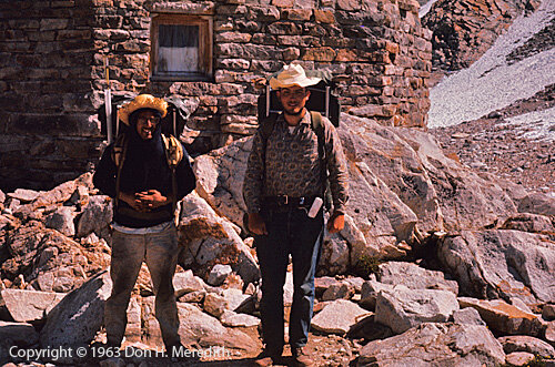
Section 3: Evolution Basin / Muir Pass Area
Slide 10 — Russ and Dana Gilbert at Muir Pass. We met Russ and Dana at Evolution Lake. Like us, they were hiking the length of the Muir Trail. We shared the trail with them over Muir Pass to Little Pete Meadows. Thanks for the help and the companionship, guys!
Section 3: Evolution Basin / Muir Pass Area
Slide 11 — These rough looking guys are just Carl and I at Muir Pass, after more than a couple of weeks on the trail.
Section 4: Muir Pass to Mather Pass
After leaving Muir Pass, Carl and I hiked to Little Pete Meadows on the Middle Fork of the Kings River, a very beautiful river valley. At Little Pete, we met Jim Dixon, John Welcomb and Bob Paris, who came over Bishop Pass with our food drop to join our hike. Bob's knee was better now and he was ready to finish the trip.
Slide 12 — Le Conte Canyon of the Middle Fork of the Kings River


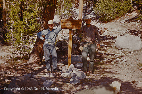
Section 4: Muir Pass to Mather Pass
Slide 13 — The Crew on Mather Pass (12,050 ft.; 3,674 m)
(l-r) Bob Paris, John Welcomb, Carl Deden

Section 4: Muir Pass to Mather Pass
Slide 14 — The Northern Palisades from Mather Pass

Section 5: South Fork of the Kings River
Here the trail stays high, traversing close to the crest of the Sierra Nevada from Mather Pass to Forester Pass on the Kings-Kern Divide. Excellent views of high mountains, lakes and meadows are seen at every turn.
Slide 15 — South Fork of the Kings River

Section 5: South Fork of the Kings River
Slide 16 — Fish caught at Woods Creek; John Welcomb, Carl Deden, Bob Paris

Section 5: South Fork of the Kings River
Slide 17 — Rae Lake
Section 5: South Fork of the Kings River
Slide 18 — Center Basin Trail Junction; Bob Paris and Don

Section 6: "The Grand Crescendo"
This section of the trail in Sequoia National Park is the end of the crest described by John Muir as the "grand crescendo" of the Sierra. Here the crest rises to a series of 14,000-foot (4,270 m) peaks, culminating in Mount Whitney, before rapidly lowering in elevation and grandeur. The trail hugs the crest, only dropping below treeline for camping, and culminates at its end at the summit of Mount Whitney (highest mountain in the lower 48 United States).
Slide 19 — Crabtree Meadows

Section 6: "The Grand Crescendo"
Slide 20 — Sunrise from the summit of Mount Whitney - We spent the night on the summit of Mount Whitney with a bunch of people who had hiked up from the east.

Section 6: "The Grand Crescendo"
Slide 21 — Dawn shadow of summit on Smithsonian shelter, Mount Whitney. John Welcomb in left foreground.

Section 6: "The Grand Crescendo"
Slide 22 — Looking East into the Owens River Valley from the summit of Mount Whitney
Section 6: "The Grand Crescendo"
And so ended a trip the memory of which has been forever embedded in my mind. I am glad we had the opportunity to do it at that time. I hope that many others have enjoyed the beauty and adventure of this wonderful wilderness as my friends and I had that August so many years ago.
Slide 23 — Don on summit of Mount Whitney (14,496 ft.; 4,420 m)
